Posts

Showing posts from November, 2024

Module 5: Unsupervised & Supervised Classification

Image
  Land Use Classification: A Study of Germantown, Maryland Introduction Understanding land use is vital for urban planning and environmental management. Using supervised classification techniques in ERDAS Imagine, we analyzed satellite imagery of Germantown, Maryland, to map various land use types and their distribution across the region. The results provide a snapshot of the area's development and natural resources, supporting sustainable growth initiatives like Maryland’s "Smart, Green, and Growing" plan. Methodology The classification process began with collecting spectral signatures for eight land use categories: Urban/Residential Roads Grass Deciduous Forest Mixed Forest Fallow Fields Agriculture Water To ensure accuracy, these signatures were refined using tools like the Region Growing Seed Tool. Using a combination of bands (Red: 6, Green: 5, Blue: 4), we classified the entire image with the Maximum Likelihood algorithm, producing a thematic raster map. A distance ...

Module 4 Lab: Spatial Enhancement, Multispectral Data, and Band Indices

Image
Spatial Enhancement and Multispectral Analysis This week's lab assignment included several exercises to further familiarize ourselves with ERDAS Imagine and to switch between programs since both ERDAS and ArcGIS Pro are best used in conjunction. Our primary focus in the lab centered around the Olympic Mountains in Washington State. The Process: A Detailed Look at Exercise 7 The culmination of our project was Exercise 7, where we synthesized the skills learned throughout our remote sensing course. We followed a meticulous four-step process to identify and map distinct environmental features: Histogram Analysis: We began by examining the histograms for each satellite data layer, looking for spikes that denote predominant pixel values. These spikes helped us pinpoint areas of interest by showing where features occur frequently and have consistent reflectance properties. Grayscale and Multispectral Viewing: Next, we analyzed the image in grayscale to identify contrast differences mor...

Module 3a: Intro to ERDAS Imagine and Digital Data

Image
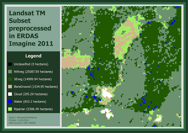
Introduction to ERDAS Imagine  This map illustrates a classified image of forested lands in Washington State, beginning with data preparation in ERDAS Imagine. Although ERDAS Imagine has map-making capabilities, the subset data was transferred to ArcGIS Pro to create the final map product. In ERDAS Imagine, a new field was added to the attribute table, and a specific area of the image was selected for export. This preprocessing step enables smooth integration into ArcGIS Pro, where the final map, showcasing detailed land cover types, is produced. This workflow demonstrates the combined power of ERDAS Imagine for data classification and ArcGIS Pro for map creation, especially when handling complex spatial data.