Posts

Showing posts from February, 2024

Georeferencing in ArcGIS

Image
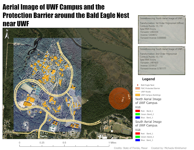
This week's lab assignment concentrated on georeferencing an unfamiliar raster image of the UWF campus to establish vector data, including buildings and roads indicated in yellow and orange. Additionally, we utilized Residual and Root Mean Square (RMS) errors to gauge the precision of the adjusted raster data. The RMSE indicates accuracy in spatial analysis and remote sensing, where a lower value suggests higher accuracy. However, it's crucial to note that accuracy relies on the quality of the Control Points data rather than solely on the image itself, emphasizing the importance of ensuring user visual accuracy. The RMSE measures discrepancies between predicted (or calculated values) and observed values, with each difference termed residual. In addition, the lab had us digitizing and editing new buildings, like the UWF gym, and roads, like Campus Lane, to the features. The map above shows the transformed raster aerial images of UWF campus in relation to the known UWF building a

Data Points and Geocoding

Image
  This week's exercise focused on creating our own spatial data using tables instead of the "ready-made" shapefiles or feature classes. In other words, we used Excel tables to organize and clean up data we collected from other websites. This exercise used Manatee County's school names and address data from the Florida Department of Education, which needed to be cleaned up before it could be used in ArcGIS, and data from the U.S. Census Bureau about Florida Counties and Manatee County. Why did we need the U.S Census Bureau information? We needed the street names in Manatee County (tl_2020_12081_edges that was projected to NAD1983 (2011) Harn State Plane Florida West FIPS 0902 Feet and renamed Edges_HarnSP) recorded in the U.S.C.B. shapefile. With that information, we were able to set up an address locator in order to geocode known school locations based on their address and zip codes. The screenshot above shows the results of the Excel Table clean-up and geocoding in o

GIS Vectors

Image
  This week's lab assignment finally dived into spatial analysis and how to perform the GIS analyses. The first part of the lab prepared us on the iterative process that involves working on projects. The following seven steps are a good baseline on the typical workflow, where several steps may have to be repeated based on new realizations to the analysis:      1. Define the problem      2. Define the criteria      3. Identify the data you need      4. Plan the analysis      5. Prepare the data for analysis      6. Execute the analysis      7. Examine and present the results Overall, this lab was the first introduction into diving deeper into our dataset, creating new files, and performing analyses in order to examine and present the results. The map of above shows possible camp sites in De Soto National Park near Hattiesburg, Mississippi. In order to find the potential sites, multiple tools such as Buffer, Union, Erase, and Multipart to Singlepart were used to manipulate the data s

GIS Map Projections

Image
  This week's lab exercise looked at the importance of map projections in GIS, especially when using multiple datasets. The map above shows four counties in Florida that are displayed using the Albers Conical Equal Area, NAD 1983 UTM Zone 16N, and NAD 1983 HARN State Plane Florida North FIPS 0903 (US Feet) map projections. As the table within the map shows, the areas of the counties vary depending on the map projections. The best map projections are ones that shows the least distortion between map features. For example, The UTM projection is best when used the map features fit within one UTM zone, which is not the case for showing the entire state of Florida. The same can be said for the Florida State Plane that is dependent on the region of interest. Therefore, the map projection would need to be Albers since it minimizes distortion between its standard parallels.  Overall, this lab illustrates how important it is to use accurate map projections since it can cause distortions betw