Posts

Showing posts from June, 2024

M6 - Geometries

Image
Completed TXT file  Description of Screenshot In the screenshot, you can see the TXT file, which includes: Feature OID Vertex ID X coordinate Y coordinate Name of the river feature The python script created the TXT file, writes to the TXT file point data for all vertices of the "rivers.shp" with all of the above information. 

M5 - Exploring & Manipulating Spatial Data using Python

Image
 Screenshots of Script Results Description of Script The script successfully managed geospatial data in ArcGIS by creating a file geodatabase, copying feature classes, and extracting specific information about 'County Seat' cities. Excluding those with unknown population data, the final output is a populated dictionary containing the names and populations of these cities. The results displayed in the screenshot confirm the accurate execution of the script and the correct manipulation of the data. Flowchart of Script

M4 - Geoprocessing

Image
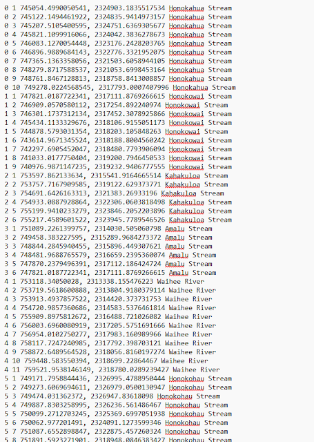
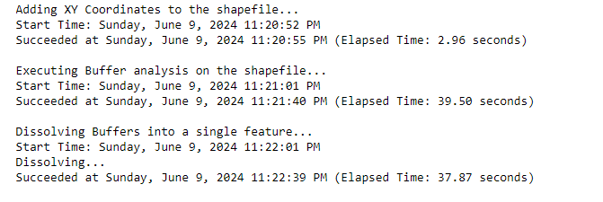
Successful Screenshot of Results   Discussion of Screenshot The above screenshot shows the successful execution of my geoprocessing script in ArcGIS Pro. The script performed the following tasks: Added XY Coordinates The script added XY coordinates to the 'hospitals' shapefile. As indicated by the start and end times, this task was completed in just 2.96 seconds. Created a 1000 Meter Buffer A 1000-meter buffer was created around each hospital. This step took a bit longer, with a completion time of 39.50 seconds. Dissolved the Buffers into a Single Feature: The individual buffers were then dissolved into a single, continuous feature. The dissolution process took 37.87 seconds, as shown in the elapsed time. This step could be completed alongside the buffer analysis.  Other Notes Python, especially with ArcGIS Pro, seems flexible and tailored to the user. For example, I could create my own script, which can use functions similar to the model's. This means that if I’m very fami

M3 - Debug & Error Handling

Image
 Script 1 Objective: Fix errors in Mod3_Script1_Template.py to list field names from parks.shp. Flowchart Output for Script 1 After Corrections Script 2 Objective: Fix errors in Mod3_Script2_Template.py to list layer names from TravisCountyAustinTX.aprx. Flowchart Output for Script 2 After Corrections Script 3 Objective: Modify Mod3_Script3_Template.py to handle errors using try-except statements without fixing the errors. Flowchart Output for Script 3 After Try-Except Statements In Mod3_Script3_Template.py, the script is divided into two parts: Part A and Part B. Part A: This part of the script is intentionally left with an error to demonstrate error handling. Instead of the program crashing and not moving further, I used a try-except statement to catch any errors and print an error message. The error message while also print what went wrong before continuing on to Part B. This is a crucial aspect of debugging since it provides immediate feedback on issues within the code. Part B: