Posts

Showing posts from March, 2024

M2 Lab: Typography

Image
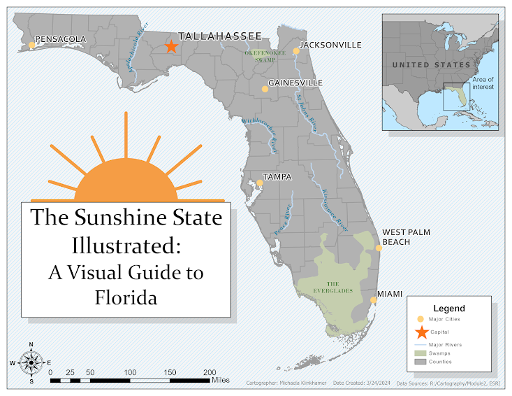
  Delving Into Typography and Labeling The recent lab took us on an insightful journey into mapmaking, focusing on Florida. The project highlighted typography's role in enhancing maps far beyond simple geographic representation, merging geography with the art of cartography to emphasize informative design. Objective Our task involved labeling Florida's map to include cities, rivers, and natural landmarks, adhering to typographic principles. Using ArcGIS Pro, we delved into computer cartography, prioritizing map design essentials and text placement to boost readability. The outcome was a Florida map pinpointing critical locations and distinguishing feature types with unique labels. The lesson instructions gave insight into which fonts are selected and why, such as serif font for natural features and sans serif for cultural. Before this class I didn't know the difference between the two typeface categories, but Serif typefaces have "little feet" that extend of the l

M1 Lab : Map Critique

Image
The Cartographic Journey Delving into the realm of cartography, we find a world where art meets science, crafting a medium that efficiently conveys information. Maps do more than show routes; they serve as a canvas for complex data, presented in a way that speaks clearly to its viewers. The design of a map is a powerful factor in its utility and its ability to leave an imprint on those who use it. Our latest lesson delved into this interplay, dissecting maps to find the harmony between visual appeal and the conveyance of information. Southport Bicycle Map: The Intersection of Charm and Function Consider the Southport Bicycle Map—a paragon of cartographic elegance. Its mission? To deftly navigate cyclists through the charming byways and picturesque vistas of Southport. Achieving this, the map marries simplicity with sophistication, balancing practicality with the quaint allure of a seaside town. The map's strengths lie in its clear focus on the cyclists' pathways. Solid and dash

About Me: Exploring the World Through GIS

  About Me Welcome to my corner of the GIS Course Blog! I'm excited to introduce myself and share my journey into the world of Geographic Information Systems (GIS), guided by a passion for wildlife science and a newfound love for data analysis. Throughout my academic pursuits in Wildlife Science, I've been captivated by the intricacies of ecological systems and biodiversity conservation. I cherish fieldwork and interacting with wildlife, but I've discovered my true passion lies in data analysis and interpretation. While I look forward to studying wildlife in their natural habitats, I found myself drawn more to collecting and analyzing data, uncovering patterns, and deriving insights that inform conservation strategies. This realization led me to explore the intersection of wildlife science and data analysis, ultimately guiding me toward the dynamic field of GIS. Why I Joined the Program During my undergraduate journey for my Bachelor of Science in Fisheries and Wildlife Sci

Final Project

Image
  The Bobwhite-Manatee Transmission Line Project showcased the intricate dance between technological advancement and environmental stewardship. Through persistent GIS analyses, the project navigated the delicate balance of infrastructure development with ecological and social considerations. This journey highlighted the importance of integrating community input and environmental sensitivities into planning and demonstrated GIS's power in crafting solutions that respect nature and neighborhood. The map above shows the basemap for the Study Area. I found it surprisingly difficult to create my own basemap since I've always taken advantage of the ones provided by ArcGIS Pro. Overall, this was one of the most influential projects I've done because this was required using a combination of provided data as well as having to collect and download my own data to fit within the defined requirements. I definitely learned that you can become quickly overwhelmed with layers you create an